
Flooding around Coles Hill, Va, proposed Uranium Mill and Mine
Comments: Please notice, very important about uranium mills from EPA, mentions Virginia! Thanks Sarah for the head ups!
Contact EPA with Comments: EPA: Revisions to National Emission Standards for Radon Emissions from Operating Mill Tailings: Virginia is part of this
Hello,
I wanted to bring to your attention the Environmental Protection Agency (EPA) proposed rule that makes changes to regulations applicable to radon emissions from operating uranium mill
tailings impoundments and evaporation ponds.
Part of the rule talks about impoundments in areas such as Virginia.
EPA says everything will be OK, but I am sure you would think otherwise.
See quote below. There will be a 90-day comment period once the proposed rule in published
in the Federal Register. Link to Proposed Rule to be Issued:
The rule also impacts the White Mesa Mill in Utah. I will have a lot to say.
Please share this information, since I am sure you all would want to comment. Experiences
with coal ash is very relevant.
My very best to you,
Sarah
______________________________

______________________________
Text of the proposed rule signed by Administrator Gina McCarthy on April 17, 2014. Upon publication of this proposed rule in the Federal Register, this pre-publication version will be replaced with a link to the official Notice of Proposed Rulemaking.
ENVIRONMENTAL PROTECTION AGENCY 6560-50-P
40 CFR Part 61
Revisions to National Emission Standards for Radon
Emissions from Operating Mill Tailings
Pages 111 - 112
V. Other Issues Generated by Our Review of Subpart W

C. Weather Events
In the past, uranium recovery facilities have been
located in the western regions of the United States. In
these areas, the annual precipitation falling on the
impoundment, and any drainage area contributing surface
runoff to the impoundment, has usually been less than the
annual evaporation from the impoundment.

Also, these facilities have been located away from regions of the
country where extreme rainfall events (e.g., hurricanes or
flooding) could jeopardize the structural integrity of the
impoundment, although there is a potential for these
facilities to be affected by flash floods, tornadoes, etc.
country where extreme rainfall events (e.g., hurricanes or
flooding) could jeopardize the structural integrity of the
impoundment, although there is a potential for these
facilities to be affected by flash floods, tornadoes, etc.

Tornadoes in Pittsylvania County, VA: Area of proposed Uranium Mill/Mine
Now, however, uranium exploration and recovery in the U.S.
has the potential to move eastward, into more
climatologically temperate regions of the country, with
south central Virginia being considered for a conventional
uranium mill.
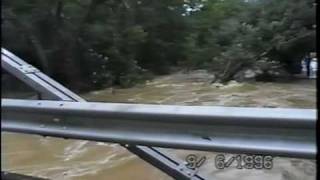
A home video of the Flood of '96, Hurricane Fran, Coles Hill Area: http://www.youtube.com/watch?v=F7mcUYAi_O4
In determining whether additional measures
would be needed for impoundments operating in areas where
precipitation exceeds evaporation, a review of the existing
requirements was necessary.
The proposed revisions to Subpart W will continue to
require owners and operators of all impoundments to follow
the requirements of 40 CFR 192.32(a)(1). That particular
regulation references the RCRA surface impoundment design
and operations requirements of 40 CFR 264.221. At 40 CFR
264.221(g) and (h) are requirements that ensure proper
design and operation of tailings impoundments. Section
264.221(g) states that impoundments must be designed,
constructed, maintained and operated to prevent overtopping
resulting from normal or abnormal operations; overfilling;
wind and rain action (e.g., a two foot freeboard
requirement); rainfall; run-on; malfunctions of level
controllers, alarms and other equipment; and human error.
Section 264.221(h) states that impoundments must have dikes
that are designed, constructed and maintained with
sufficient structural integrity to prevent massive failure
of the dikes. In ensuring structural integrity, it must not
be presumed that the liner system will function without
leakage during the active life of the unit.
Since impoundments at uranium recovery facilities have
been and will continue to be required to comply with the
requirements of 40 CFR 192.32(a)(1), they are already
required to be designed to prevent failure during extreme
weather events. As we stated in Section IV B.2., we believe
the requirements of 40 CFR 192.32(a)(1) contain enough
safeguards to allow for the placement of tailings and yet
provide an early warning system in the event of a leak in
the liner system. Therefore, we are proposing to include
these requirements in the Subpart W requirements without
modification.
would be needed for impoundments operating in areas where
precipitation exceeds evaporation, a review of the existing
requirements was necessary.
Average Number of Days with 0.1 Inch or More Precipitation in a Year (this gives an indication of the number of days in a year that it is useful to have an umbrella), #65
| Pittsylvania County | |
| Virginia | |
| U.S. |
require owners and operators of all impoundments to follow
the requirements of 40 CFR 192.32(a)(1). That particular
regulation references the RCRA surface impoundment design
and operations requirements of 40 CFR 264.221. At 40 CFR
264.221(g) and (h) are requirements that ensure proper
design and operation of tailings impoundments. Section
264.221(g) states that impoundments must be designed,
constructed, maintained and operated to prevent overtopping
resulting from normal or abnormal operations; overfilling;
wind and rain action (e.g., a two foot freeboard
requirement); rainfall; run-on; malfunctions of level
controllers, alarms and other equipment; and human error.
Section 264.221(h) states that impoundments must have dikes
that are designed, constructed and maintained with
sufficient structural integrity to prevent massive failure
of the dikes. In ensuring structural integrity, it must not
be presumed that the liner system will function without
leakage during the active life of the unit.
Humidity
Annual Average Humidity, #5
| Pittsylvania County | |
| Virginia | |
| U.S. |
Since impoundments at uranium recovery facilities have
been and will continue to be required to comply with the
requirements of 40 CFR 192.32(a)(1), they are already
required to be designed to prevent failure during extreme
weather events. As we stated in Section IV B.2., we believe
the requirements of 40 CFR 192.32(a)(1) contain enough
safeguards to allow for the placement of tailings and yet
provide an early warning system in the event of a leak in
the liner system. Therefore, we are proposing to include
these requirements in the Subpart W requirements without
modification.
Report mentions Virginia:
Technical and Regulatory Support to Develop a Rulemaking to Potentially Modify the NESHAP
Subpart W Standard for Radon Emissions from Operating Uranium Mills
(40 CFR 61.250)
U.S. Environmental Protection Agency
Office of Radiation and Indoor Air
1200 Pennsylvania Avenue, N.W.
Washington, DC 20460
February 2014Table 4: Proposed New Conventional Uranium Milling Facilities
Virginia Uranium Coles Hills N.A. VA
5.5.4 The Role of Weather Events
In the past, uranium recovery facilities have been located in the western regions of the United
States. In these western regions, the annual average precipitation (see Figure 16) falling on the
impoundment is less than the annual average evaporation (see Figure 17) from the impoundment.
Also, these facilities are located away from regions of the country where extreme rainfall events
(e.g., hurricanes or flooding) could jeopardize the structural integrity of the impoundment,
although there is a potential for these facilities to be affected by flash floods, tornadoes, etc.
However, recent uranium exploration in the United States shows the potential to move eastward,
into more climatologically temperate regions of the country. South central Virginia is now being
considered for a conventional uranium mill (e.g., the Coles Hills, see
Table 4). To determine whether additional measures would be needed for impoundments
operating in areas where precipitation exceeds evaporation, a review of the existing requirements
was necessary.
Figure: http://www.epa.gov/radiation/docs/neshaps/subpart-w/subpartwfianl-eia-bid.pdf
6.2.1 Conventional Mill Cost Estimate
The base case economic costs for development of a new conventional mill were developed using
data from the proposed new mill at Piñon Ridge in Colorado (Edge 2009). Although cost
estimates for other conventional mills were reviewed, e.g., Coles Hill (Lyntek 2010), Church
Rock (BDC 2011), the Piñon Ridge cost estimate was selected for the base case because it is
believed to be the furthest advanced. Specific cost data obtained from the Piñon Ridge project
(i.e., Edge 2009, Tables 7.1-1 and 7.1-2) were for land acquisition and facility construction,
operating and maintenance, decommissioning, and regulatory oversight. While the Piñon Ridge
project supplied the mill design parameters and the overall magnitude of the cost, additional data
on the breakdown of the capital and operating costs were taken from the Coles Hill uranium
project located in Virginia (Lyntek 2010).
Lyntek Inc. and BRS Engineering 2010. “Preliminary Economic Assessment on the Coles Hill
Uranium Property,” prepared for Virginia Uranium Inc. and Virginia Energy Resources Inc.,
December 2010.
SC&A (S. Cohen & Associates) 2008. “Report on the Review of Method 115 to Monitor Radon
Emissions from Uranium Tailings,” Contract Number EP-D-05-002, Work Assignment
No. 4-11, Task 6, SC&A, Inc., Vienna, Virginia, September 25, 2008.
SC&A (S. Cohen and Associates) 2010. “Risk Assessment Revision for 40 CFR Part 61
Subpart W – Radon Emissions from Operating Mill Tailings, Task 5 – Radon Emission from
Evaporation Ponds,” Contract Number EP-D-10-042, Work Assignment No. 1-04, Task 5,
SC&A, Inc., Vienna, Virginia, November 2010.
SC&A (S. Cohen and Associates) 2011. “Risk Assessment Revision for 40 CFR Part 61
Subpart W – Radon Emissions from Operating Mill Tailings, Task 4 – Detailed Risk Estimates,”
Contract Number EP-D-10-042, Work Assignment No. 1-04, Task 4, SC&A, Inc., Vienna,
Virginia, March 25, 2011.
http://www.epa.gov/radiation/docs/neshaps/subpart-w/subpartwfianl-eia-bid.pdf
VDEQ (Virginia Department of Environmental Quality) 2000. “Landfill Cost Estimate Form.”
http://www.epa.gov/radiation/docs/neshaps/subpart-w/subpartwfianl-eia-bid.pdf
Great info that Uranium Mill and Mining will not work in VA:
Pittsylvania County Weather: http://www.usa.com/pittsylvania-county-va-weather.htm
Historical Weather
Heating Cost Index, #46
Pittsylvania County
|
193.71 |
Virginia
|
200.82 |
U.S.
|
212.91 |
Cooling Cost Index, #62
Pittsylvania County
|
127.01 |
Virginia
|
126.27 |
U.S.
|
139.42 |
The Heating Cost Index and the Cooling Cost Index are indicators of the relative heating and cooling cost of an area. They were calculated based on the average temperate and duration of the hot and cold days for the area. Please note, the actual heating cost and cooling cost are also dependent on other factors specific to individual residences such as the size of the house, the insulation condition, and the equipment efficiency, etc.
Average Temperature
Annual Average Temperature, #60
Pittsylvania County
|
56.0 °F |
Virginia
|
55.5 °F |
U.S.
|
54.5 °F |
Ranks: Average Max. Temperature: #60, Average Min. Temperature: #48
Precipitation
Average Annual Precipitation, #50
Pittsylvania County
|
43.93 inches |
Virginia
|
42.76 inches |
U.S.
|
38.67 inches |
Total Monthly PrecipitationPittsylvania CountyVirginiaU.S. (Average of All Locations)JanFebMarAprMayJunJulAugSepOctNovDec2.533.544.5Amount (inches)
Average Number of Days with 0.1 Inch or More Precipitation in a Year (this gives an indication of the number of days in a year that it is useful to have an umbrella), #65
Pittsylvania County
|
73.59 days |
Virginia
|
74.79 days |
U.S.
|
66.51 days |
Number of Days with 0.1 Inch or More PrecipitationPittsylvania CountyVirginiaU.S. (Average of All Locations)JanFebMarAprMayJunJulAugSepOctNovDec45678Days
Snow
Average Annual Snowfall, #96
Pittsylvania County
|
9.24 inches |
Virginia
|
14.85 inches |
U.S.
|
23.27 inches |
Total Monthly SnowfallPittsylvania CountyVirginiaU.S. (Average of All Locations)JanFebMarAprMayJunJulAugSepOctNovDec-202468Inches
Average Number of Days with 1 Inch or More Snow Depth in a Year, #109
Pittsylvania County
|
4.73 days |
Virginia
|
11.43 days |
U.S.
|
27.17 days |
Number of Days with 1 Inch or More Snow DepthPittsylvania CountyVirginiaU.S. (Average of All Locations)JanFebMarAprMayJunJulAugSepOctNovDec-2.502.557.510Days
Humidity
Annual Average Humidity, #5
Pittsylvania County
|
80.64% |
Virginia
|
76.77% |
U.S.
|
77.52% |
Monthly Average HumidityPittsylvania CountyVirginiaU.S. (Average of All Locations)JanFebMarAprMayJunJulAugSepOctNovDec65707580859095Humidity (%)
Wind Speed
Annual Average Wind Speed, #16
Pittsylvania County
|
22.12 mph |
Virginia
|
19.32 mph |
U.S.
|
16.93 mph |
Monthly Average Wind SpeedPittsylvania CountyVirginiaU.S. (Average of All Locations)JanFebMarAprMayJunJulAugSepOctNovDec102030400Wind Speed (mph)
* The temperature, snow fall, and precipitation information on this page were calculated from the historical data of 18,000+ U.S weather stations for the period of time from 1980 to 2010. The humidity and wind speed information were calculated from data from 15,000 worldwide stations for the period of time from 1980 to 2010.
Pittsylvania, Canada dissimilar (Uranium Mining)

Pittsylvania, Canada dissimilar
Letter to the Editor | Posted: Wednesday, October 2, 2013 6:00 amTo the editor:
I read with interest the letter, “Homes, uranium mines coexist,” (Sept. 27, A8). I do not doubt the veracity of Kevin Scissons, former chief regulator for Canada’s uranium operations. However, I do believe we are comparing apples to oranges when discussing the proposed uranium mine in Pittsylvania County and the existing mines in Canada’s northern Saskatchewan Province.
To put the two affected populations in proper perspective, the hamlet of Wollaston Lake and adjacent village of Wollaston Post have 1,380 inhabitants combined. This center is roughly 26 miles from the mines and constitutes the largest concentration of people for hundreds of miles.
Given the aquifer underlying Pittsylvania County, which stretches from Charlottesville in the north to Charlotte, N.C., in the south, and the nearby rivers enjoyed by all those folks east of Pittsylvania County, I believe we are talking about a population in the millions.

PRINCIPAL IGNEOUS AND METAMORPHIC-ROCK AQUIFERS
http://water.usgs.gov/ogw/aquiferbasics/volcan.html
Let’s talk about climate and geology. I have several concerns. Unlike northern Saskatchewan, which has a climate best described as coldly inhospitable, Pittsylvania County is subject to northeasters, hurricanes, and tornados.
Enough rain can fall to cause serious drainage problems to any containment barrier. With tornados, radioactive waste (tailings) can be deposited just about anywhere.
This does not touch on the potential disaster associated with earthquakes. Forces of nature do not concern themselves with property lines.
This brings us to the point of the proposed “unbreachable” concrete containment barriers for the radioactive waste. Concrete ages and decomposes. The rubber used to line the concrete has an even shorter life span.
The point is we are not living in northern Saskatchewan. Having safety regulations that only protect adjacent properties does not address river, aquifer or air contamination.
Furthermore, materials technology cannot address the problems of stress due to aging, catastrophic breach due to earthquake and subsequent leaching of radioactive contaminants into the aquifer, or violent weather, which can undo the best efforts of man.
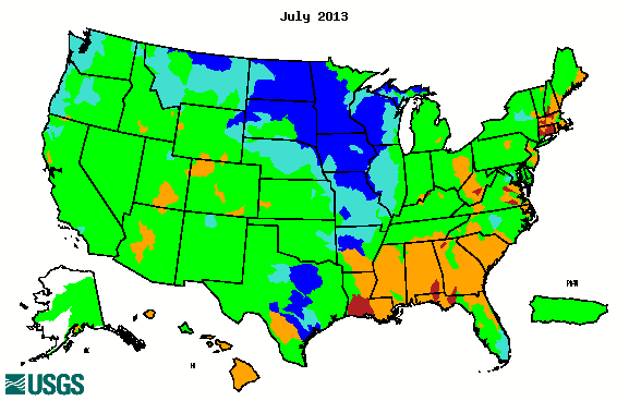
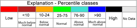
http://waterwatch.usgs.gov/index.php?ym=201307&m=nwc
With all due respect to Henry Hurt and Kevin Scissons, I am not in the least convinced that any regulations conceived by even the most concerned and altruistic politicians will be able to address the potential disaster of uranium mining in Virginia.
JEFFREY R. CARSON
Danville
Uranium Mining - A Risky Experiment: Hurricanes, Tornadoes, Earthquakes
In the last century, the Commonwealth has been hit by at least 78 category-strength hurricanes, including Hurricane Camille in 1969, which dumped 31 inches of rain on central Virginia. In 2011, at least 37 tornadoes were recorded in Virginia, including one in Halifax County about 20 miles from the Coles Hill site. And in August, 2011, an earthquake of 5.8 magnitude rocked Virginia; its epicenter was just 125 miles from Coles Hill.
Virginia has no regulations for uranium mining, and, with less than 1% of the state's general fund revenues dedicated to environmental programs, is ill-prepared to sufficiently oversee the industry. The federal government has virtually no experience regulating uranium mining in a wet climate.
The only peer‐reviewed study of the issue, conducted by the National Academy of Sciences, validates many of our concerns, including risks to water quality from radioactive tailings, and the fact that current federal regulations are inadequate to protect public health and the environment from potential impacts of uranium mining in Virginia. The National Academy’s work provides clear, objective evidence that the state’s ban on uranium mining should not be lifted.
http://www.southernenvironment.org/cases-and-projects/uranium-mining-a-risky-experiment


